How to use Survey Calculators / طريقة استخدام الحاسبات المساحية
Seventeen coordinate geometry and field reduction calculators: inverse, polar, area, intersection, resection, least squares, curves, profiles, sections, levelling and volumes.
سبع عشرة حاسبة لهندسة الإحداثيات واختزال الأرصاد: الحل العكسي والقطبي والمساحة والتقاطع والتقاطع الخلفي والمربعات الصغرى والمنحنيات والقطاعات والميزانية والأحجام.
Feature status: · حالة الميزة: Working · يعملPartial / experimental · جزئي / تجريبيNot available yet · غير متاح بعدKnown issue · مشكلة معروفة
What it is for · الغرض من الأداة
Use the calculators for quick office and field computations that do not need a full project: check a setting-out point, compute a curve table, close a parcel description or reduce a level book. Everything runs in your browser.
استخدم الحاسبات للحسابات المكتبية والحقلية السريعة التي لا تحتاج مشروعاً كاملاً: فحص نقطة توقيع، أو حساب جدول منحنى، أو قفل وصف قطعة أرض، أو حساب دفتر ميزانية. كل شيء يعمل في متصفحك.
Inputs and supported formats · المدخلات والصيغ المدعومة
Coordinates (Easting, Northing), angles, distances, levels. Multi-row inputs take one line per point or row, comma separated.
الإحداثيات (الشرقي والشمالي) والزوايا والمسافات والمناسيب. المدخلات متعددة الصفوف تأخذ سطراً لكل نقطة أو صف، مفصولة بفواصل.
Decimal degrees or DMS symbols (auto), or packed D.MMSS (45.3000 = 45°30′00″).
درجات عشرية أو رموز DMS (تلقائي)، أو صيغة D.MMSS المضغوطة (45.3000 = 45°30′00″).
Scale factor needs a projected CRS picked from the library.
حاسبة معامل المقياس تحتاج نظاماً مسقطاً من المكتبة.
Step by step · خطوة بخطوة
Pick a calculator
اختر الحاسبة
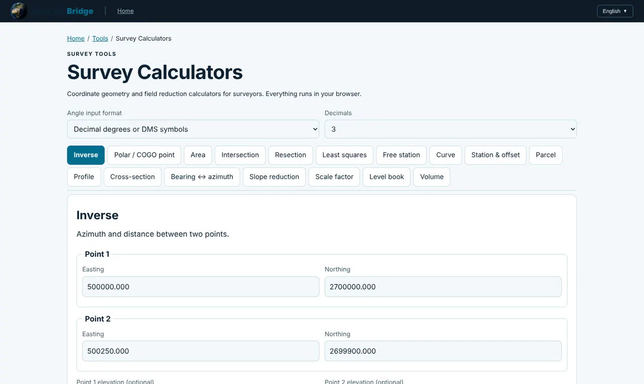
Click one of the 17 tabs. A one-line description under the title says what it computes.
اضغط أحد التبويبات السبعة عشر. يوضح السطر أسفل العنوان ما تحسبه.
Set the options
اضبط الخيارات
Choose the angle format and the number of decimals for the results.
اختر صيغة الزوايا وعدد الخانات العشرية للنتائج.
Enter the data
أدخل البيانات
Fill the fields or paste rows (one point per line). Optional fields can be left empty.
املأ الحقول أو الصق الصفوف (نقطة لكل سطر). الحقول الاختيارية يمكن تركها فارغة.
Calculate
احسب
Click Calculate. Results and any warnings appear under the form; check Formulas used at the bottom of the page for the equations.
اضغط Calculate. تظهر النتائج وأي تحذيرات أسفل النموذج؛ وراجع Formulas used أسفل الصفحة لمعرفة المعادلات.
Calculators · الحاسبات
Azimuth and distance between two points.
الانحراف والمسافة بين نقطتين.
New point from a start point, azimuth and horizontal distance.
نقطة جديدة من نقطة بداية وانحراف ومسافة أفقية.
Polygon area, perimeter and centroid from coordinates (shoelace formula).
مساحة المضلع ومحيطه ومركزه من الإحداثيات (صيغة الأربطة).
Bearing–bearing, distance–distance or angle–angle (forward) intersection from two known points.
تقاطع اتجاه–اتجاه أو مسافة–مسافة أو زاوية–زاوية (أمامي) من نقطتين معلومتين.
Three-point resection (Tienstra) from horizontal circle readings to known points.
تقاطع خلفي من ثلاث نقاط (Tienstra) من قراءات الدائرة الأفقية.
Adjustment of a traverse or network from angles, directions, distances and azimuths, with standard deviations, error ellipses, residuals and statistical tests.
ضبط ترافيرس أو شبكة من الزوايا والاتجاهات والمسافات والانحرافات، مع الانحرافات المعيارية وقطوع الخطأ والبواقي والاختبارات الإحصائية.
Resection from directions (and optionally distances) to two or more known points, adjusted by least squares.
تقاطع خلفي من الاتجاهات (والمسافات اختيارياً) إلى نقطتين معلومتين أو أكثر، مضبوط بالمربعات الصغرى.
Horizontal circular curve elements and setting-out table (deflection angles and chords from the PC).
عناصر المنحنى الأفقي الدائري وجدول التوقيع (زوايا الانحراف والأوتار من PC).
Chainage and perpendicular offset of points from a polyline alignment, or the coordinates of a chainage and offset.
المحطة والإزاحة العمودية للنقاط عن محور، أو إحداثيات محطة وإزاحة معلومة.
Parcel closure from bearing/distance legs: misclosure, precision ratio, Bowditch-closed coordinates, area and perimeter.
قفل قطعة الأرض من أضلاع الاتجاه/المسافة: خطأ القفل ونسبة الدقة والإحداثيات المضبوطة ببوديتش والمساحة والمحيط.
Ground and design grades between chainages, and cut (+) or fill (−) depth at each point.
ميول الأرض والتصميم بين المحطات، وعمق الحفر (+) أو الردم (−) عند كل نقطة.
Cut and fill areas of a cross-section from ground and design lines; crossing points found exactly.
مساحات الحفر والردم في القطاع العرضي من خطي الأرض والتصميم؛ مع إيجاد نقاط التقاطع بدقة.
Quadrant bearings to whole-circle azimuths and back.
تحويل الاتجاهات الربعية إلى انحرافات دائرية والعكس.
Horizontal and vertical distance from slope distance and zenith angle.
المسافة الأفقية والرأسية من المسافة المائلة والزاوية السمتية.
Point scale factor, grid convergence, elevation factor and combined scale factor for a projected CRS.
معامل المقياس للنقطة وتقارب الشبكة ومعامل الارتفاع والمعامل المركب لنظام مسقط.
Height-of-instrument reduction with arithmetic check and distance-weighted misclosure adjustment.
حساب الميزانية بطريقة ارتفاع الجهاز مع الفحص الحسابي وتوزيع خطأ القفل حسب المسافة.
Earthwork volume from cross-section areas: average end area and prismoidal (Simpson) rule.
حجم الأعمال الترابية من مساحات القطاعات: متوسط المساحتين وقاعدة المنشور (سيمبسون).
Buttons, tabs and commands · الأزرار والتبويبات والأوامر
Inverse, Polar / COGO point, Area, Intersection, Resection, Least squares, Free station, Curve, Station & offset, Parcel, Profile, Cross-section, Bearing ↔ azimuth, Slope reduction, Scale factor, Level book, Volume.
Inverse وPolar / COGO point وArea وIntersection وResection وLeast squares وFree station وCurve وStation & offset وParcel وProfile وCross-section وBearing ↔ azimuth وSlope reduction وScale factor وLevel book وVolume.
Runs the selected calculator.
تشغيل الحاسبة المختارة.
The equations behind each calculator and common questions.
المعادلات المستخدمة في كل حاسبة والأسئلة الشائعة.
Formulas · المعادلات
Az = atan2(ΔE, ΔN) D = √(ΔE² + ΔN²)E₂ = E₁ + D·sin Az N₂ = N₁ + D·cos AzA = ½ |Σ (Eᵢ·Nᵢ₊₁ − Eᵢ₊₁·Nᵢ)|T = R·tan(Δ/2) L = π·R·Δ/180 C = 2R·sin(Δ/2)H = S·sin z V = S·cos zAverage end: V = L·(A₁ + A₂)/2 Prismoidal: V = L/3·(A₁ + 4A₂ + A₃)Outputs · المخرجات
Values, setting-out tables, residuals and statistics, ready to copy.
القيم وجداول التوقيع والبواقي والإحصاءات، جاهزة للنسخ.
Practical example · مثال عملي
Example: setting-out table for a road curve
مثال: جدول توقيع منحنى طريق
Open Curve. Radius R = 300 m, deflection angle Δ = 24°30′00″, PI chainage 1+245.600, setting-out interval 20 m.
افتح Curve. نصف القطر R = 300 م، وزاوية الانحراف Δ = 24°30′00″، ومحطة PI 1+245.600، والفاصل 20 م.
Calculate gives T = 65.14 m, L = 128.28 m, the PC and PT chainages, and a table of chords and deflection angles from the PC for every 20 m station.
تعطي Calculate T = 65.14 م وL = 128.28 م ومحطتي PC وPT وجدول الأوتار وزوايا الانحراف من PC لكل محطة كل 20 م.
Copy the table into your field sheet and set out from the PC with the total station.
انسخ الجدول إلى ورقة الحقل ووقّع من PC بجهاز التوتال ستيشن.
Limitations · القيود
- Working · يعمل
Results were validated against published worked examples (Mahun, MTSU and university course notes); see the Formulas used section.
تم التحقق من النتائج مقابل أمثلة منشورة (Mahun وMTSU ومذكرات جامعية)؛ راجع قسم Formulas used.
- Partial / experimental · جزئي / تجريبي
Plane computations: distances and areas are grid values. Apply the combined scale factor (Scale factor tab) when you need ground distances.
حسابات مستوية: المسافات والمساحات قيم شبكية. طبّق المعامل المركب (تبويب Scale factor) إذا احتجت مسافات أرضية.
- Partial / experimental · جزئي / تجريبي
Inputs are not saved between visits. For a saved, reportable traverse use the Traverse Adjustment page.
لا تُحفظ المدخلات بين الزيارات. لترافيرس محفوظ مع تقرير استخدم صفحة ضبط الترافيرس.
Troubleshooting · حل المشكلات
Angles come out wrong by a few degrees
الزوايا خاطئة ببضع درجات
Check the angle format: 45.3000 means 45°30′ only in packed D.MMSS mode.
راجع صيغة الزوايا: 45.3000 تعني 45°30′ فقط في وضع D.MMSS المضغوط.
Resection fails
فشل التقاطع الخلفي
Tienstra fails when the station lies near the circle through the three known points ("danger circle"). Use Free station with a fourth point or a distance.
تفشل طريقة Tienstra عندما تقع المحطة قرب الدائرة المارة بالنقاط الثلاث («دائرة الخطر»). استخدم Free station مع نقطة رابعة أو مسافة.
Least squares does not converge
المربعات الصغرى لا تتقارب
Give better approximate coordinates for new points and check for a blunder in one observation.
أدخل إحداثيات تقريبية أفضل للنقاط الجديدة وابحث عن خطأ جسيم في إحدى الأرصاد.
Need more help? Send us a message from the Support page.
تحتاج مساعدة أكثر؟ أرسل لنا رسالة من صفحة الدعم.
Last updated 2026-10-24 · آخر تحديث 2026-10-24